Lopez Island
population age distribution according to the 2010 US census. This graph is a
nugget of informative findings from the 100 page report “Lopez Island 2025:
Sustainable Transformation towards Resiliency” by a group of Monterey Institute
of International Studies students.
|
Tuesday, June 26, 2012
A draft report on Lopez Island 2025 is ready for review
Friday, June 22, 2012
The risks of San Juan waters becoming coal and tar sands export highways
 |
| Tar sands "oil" is actually thick sticky "bitumen". Bitumen needs to be mixed with volatile diluents to be able to pump and move in crude oil pipelines. |
In the same month, SSA Marine, a division of the world's largest cargo terminal operator Carrix, also filed an application to build North America's largest coal export at Cherry Point[2].
The oil tankers from Vancouver would skirt Waldron, Stuart and San Juan islands on the west while the coal shipping vessels would come down the Rosario Strait east of Orcas and Lopez, before heading out to the Pacific Ocean.
These two projects alone will add approximately 1,700 more large vessel trips each year[3], averaging about one every five hours.
It's simple math: the more traffic you have, the higher the likelihood of an incident. One engine failure, bad storm or imperfect maneuver between the reefs, rocks and other ships could mean devastation to the people and marine life that rely on the special ecosystems along these coasts, warned Lovel Pratt, a SJ County Council representative, as quoted in Huffington Post.[4] "When the Gulf spill happened, we had days before any of the oil came to any shore. Here, we would have hours. And we're dealing with the unique challenges of our ecology and geography that includes so much coastline and sensitive ecosystems," said Pratt in the news article. The bulk coal carriers each carry upwards of 10,000 tons of bunker oil, one of the most toxic fuels. But the worst is tar sands oil.
Unlike conventional crude tar sands oil is a mixture of sticky tar and a cocktail of toxic solvents that allow the thick bitumen to be pumped through a pipeline. In the event of a tar sands oil spill, the solvents evaporate into the surrounding air hindering the rescue efforts, and the heavier bitumen sinks -- rendering useless the conventional clean-up equipment designed to recover floating oil, as seen in the recent experience of the million-plus gallons of spilled tar sands chemicals in Michigan's Kalamazoo River. Twenty months after the spill the expensive recovery efforts continued, and 30 miles of the contaminated River remained closed to swimming, boating, fishing or even wading for the foreseeable future.[5]
If a Suezmax-class tanker, each carrying Alberta diluted bitumen 50 times the Kalamazoo spill amount, were to leak or spill in SJ waters, it is unclear if we have the technology, let alone the capacity, to handle such an incident.
The issue is further complicated by the fact that the Salish Sea straddles the U.S.-Canada border. If the ships are coming out of Canada and don't stop in a U.S. port, then Washington State has no jurisdiction. SJ residents will bear the risks but have to rely on the Canadian government for setting standards and prevention.[6]Meanwhile, the Canadian government recently decided to remove oil spill staff from Vancouver at the same time that the plan to increase tanker traffic in the area was announced.[7]
As for the WA side, the Department of Ecology estimated that a major (conventional) oil spill would cost 165,000 jobs and $10.8 billion dollars in direct economic impacts and could even wipe out the resident orca population, blanket productive fish spawning beaches with crude, and circulate aging oil throughout the Sound for years to come.[8]
Let’s get involved. Please sign petitions, talk to your neighbors and call relevant government agencies.
Tuesday, May 22, 2012
Where Tar Sands Meet the Salish Sea
Tuesday, April 17, 2012
Lopez Island and Sustainability Survey
Please click on the link below to go to the online survey or go to: http://tinyurl.com/d3ksvcf
"Island and Sustainability" class survey
The survey is designed for households, just like the U.S. Census. Please, only one survey response per household.
Your individual responses will be confidential. Your name and contact information will not be recorded unless you choose to do so. The link above will also provide more information on the class project, or if you have any questions, comments, or concerns, please do not hesitate to contact Chris and Chom, who are leading the research project. They can be reached by email at: chrisgreacen@gmail.com
Thank you again for your time and thoughtful responses to our survey.
Sincerely,
The MIIS graduate student research team.
Sunday, April 15, 2012
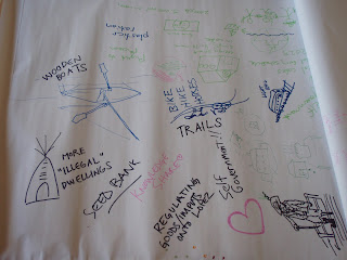
Ideas generated from the Lopez Sustainability Collaborative Fest


Wednesday, April 4, 2012
'Thinking like an island: Planning for sustainability on Lopez'
By Chris and Chom Greacen
(Photos by Steve Horn)

These were some ideas that emerged from the Lopez Sustainability Collaborative Potluck and Pizza Fest, Thursday, March 22 at the Lopez Center for Community and the Arts. The group of around a hundred Lopezians gathered to share food and discussion in an interactive process facilitated by Clive Prout. The group considered some big questions: “What will Lopez be like in the year 2025? What changes would we want to see – in transportation, in electricity and heating for our homes and businesses, in agriculture and food, in our island’s water, and how we manage waste?”
The event marked the culmination of four days of interviews and field research by 11 graduate students from the Monterey Institute of International Studies who visited Lopez as part of a semester-long class called “Thinking like an Island: Planning for sustainability on Lopez Island.” We have been teaching this class from Lopez via video-conference since February this year, with help from Faith Van De Putte who led a contingent of students while on the island.
The student’s final class project is a paper exploring one or more scenarios of enhanced sustainability and resilience, as well as a grant proposal for exploring next steps. Research work comprises gathering baseline data, understanding Lopezians’ visions for the future, and articulating next steps.
The students are interested in Lopez Island specifically because islands are recognized as crucibles of sustainable development. Globally, we are facing pressing scarcity of natural resources, including water, soil, and fossil fuels. Here on the island, the higher cost compared to the mainland prices for fuel, imported food, and just about everything else further raises the relative value of producing essentials locally and sustainably. The close-knit community and trust we share on Lopez also enables development of innovation in housing, agriculture, and energy and food that are inspirations for America and beyond.
Over the course of their four-day visit to the island, the students met with over 50 individuals and groups to understand current resource flows and Lopezians’ visions and concerns for the future. Visits included half a dozen Lopez farms, Orcas Power and Light Co-op power cable landing, the Sewer District, grocery stores, the Lopez School, the Transfer Station, and Lopez Sand and Gravel.
These visits turned up some interesting findings:
• school buses travel 176 miles on Lopez each school day;
• electricity usage in the average home at Common Ground, a sustainable net zero energy project, is about 400 kWh per month – about 40 percent of the average home on Lopez;
• essentially all electricity in San Juan County comes through two 6-inch cables that land on Lopez;
• about 700 dump truck loads of branches and roots are open-burned at the pit at Lopez Sand and Gravel every year;
• Lopez has 6,000 acres of wooded land about three acres per person, enough to potentially meet all space and heating needs on the island if properly managed;
• due to lack of composting facilities, human and food waste biosolids from the sewer district are trucked to the mainland two to four times a month for incineration;
• during the summer over 500,000 gallons of treated water per month suitable for irrigation of all but root crops from the Fisherman Bay Sewer District are released into the ocean.
The students’ project will weave these – and many other baseline facts – into an analysis of current consumption patterns and an investigation into opportunities for more resiliency and sustainability.
If you are interested in this project or seeing some photos and slideshow, visit the graduate students’ blog at blogs.miis.edu/resilientcommunities/, which chronicles the work of the students in developing the class project and will include opportunities in future weeks to comment on their emerging class project.
The site also contains a link to an online survey less than 10 minutes with important questions to fill information gaps about our reliance on imported food, petroleum and more. Your participation is greatly appreciated.


